As the Government looks to reform the planning system with an increased use of digital technologies, Esri UK wanted to find innovative solutions to planning challenges and collaborate with local authorities to bring them to life.
Geospatial technology and data have an important role to play in digital planning reform, as outlined in the Planning for the Future white paper, published by the Ministry of Housing, Communities and Local Government in 2020. The use of mapping and analytical tools was also one of the recommendations in the report A Digital Future for Planning: Spatial Planning Reimagined, released in February 2022, by the Independent Digital Task Force for Planning.
For the last year, three pilot projects have been exploring new approaches to some common problems, all designed to help make the planning process easier for everyone. Projects at Nottingham City Council, Dacorum Borough Council and South Ayrshire Council have focused on maximising the use of 3D visualisations, managing developer contributions more efficiently and improving community engagement.
Having won a competition in Spring 2022 to find innovative ideas to digitise and improve planning using geospatial technology, the councils have been working to make their projects a reality.
Nottingham City Council
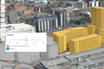
Nottingham City Council’s pilot has proven the value of using 3D visualisations integrated with other existing data, to allow constraints and impact assessments to be carried out simultaneously.
A prototype site assessment tool was built that brings together all relevant spatial data into one 3D environment, including the proposed scheme itself, plus conservation areas, site allocations, flood risk and tree cover. This has allowed planning teams to conduct 3D assessments of various constraints on a site, at the same time as a visual impact assessment, which speeds up the decision-making process. And from a technical perspective, the project has proved that this type of 3D planning is possible from any browser at the right performance levels.
The benefits are varied, from understanding what a building will look like in situ and trying different view corridors to assess its visual impact, to examining master planning issues, flood risk assessments or potential solar energy sites. The 3D visualisations can also be used to gain public feedback or other parties using images and fly-throughs.
Next steps at Nottingham include advancing the prototype site assessment tool to make it fully operational and creating some 3D showcase demonstrators to engage with internal business areas.
Dacorum Borough Council
Dacorum Borough Council’s project has built a prototype tool which visualises infrastructure and developer contributions secured through Planning Obligations on an interactive map, replacing traditional static spreadsheet data.
A map was built that plots the sources of developer contributions S106 and Community Infrastructure Levy (CIL) received and shows where the contributions have been spent. Providing this information in a spatial way gives Council officers a powerful asset which can be used for planning, decision making and monitoring.
One of the most obvious findings of the pilot has been how geospatial technology can create interactive experiences with this financial data – particularly the ability to change static spreadsheets into more meaningful, visual data that can be used for multiple purposes.
Work is continuing on the tool to integrate regular, automated data feeds to make the application more streamlined and current. Once this work is completed the intention is to make the tool available online to allow the public to understand the process and engage in infrastructure funding and planning.
South Ayrshire Council
South Ayrshire Council’s outcome has been the creation of a community consultation platform, with interactive methods of engagement to improve community and other stakeholder involvement in Local Development Plans.
The collaboration between the council and Esri UK has created a platform designed to keep the public and other parties engaged and informed, to strengthen the local planning authority’s relationship with its communities and reach better planning outcomes.
Built using Esri UK’s community engagement platform ArcGIS Hub, it keeps citizens informed via social media and asks their opinion on what they feel are the main planning issues within their community. The system plots these comments on an interactive map to highlight any issues and reveal policy engagement hotspots.
From an internal perspective, South Ayrshire’s planning officers now use a new Local Development Plan map dashboard, containing sites, stakeholder assessments and public comments, allowing them to assess the site and run a report on the selection process. Previously, this reporting was done manually and separately in Excel.
The new digital tools have helped to improve the LDP process and enhance community and stakeholder engagement, raise workload capacity, eliminate participation barriers and drive better outcomes.
Positive outcomes
What the competition process highlighted was that finding new ways of applying geospatial technology in planning opened the minds of councils as to what problems could be solved.
With almost 50 entries, there were many other great suggestions about where geospatial technology could help advance the digitisation of planning. Overall, the pilots have revealed how digital solutions can help shape the future of the planning process by delivering significant cost and time savings.
Stephen Croney is head of sector for Land, Property and Planning at Esri UK