GIS, spatial data, and consultancy services company, Cadcorp, has released Cadcorp SIS 9.1. This new software release delivers new and improved core functionality and significantly enhanced capabilities to Cadcorp SIS Desktop, Cadcorp SIS WebMap and Cadcorp GeognoSIS®. Cadcorp continues to provide industry-leading support for Ordnance Survey® (OS®) GB data and services. In SIS 9.1, users will be able to gain maximum value from the recently released Ordnance Survey National Geographic Database (OS NGD) API – Features via a new dedicated user interface. Cadcorp is hosting a webinar for Local Government that demonstrates some of these new features. Find out about the Cadcorp webinar here.
More than ever, organisations are using location both to respond to service user needs and to meet stakeholder requirements. This major software release from Cadcorp has been designed to help derive even greater insight from data that, in turn, can be used for actionable intelligence.
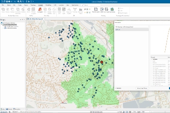
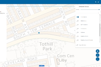
 The SIS Desktop user interface has undergone a refresh. It introduces a simplified ribbon with an updated quick access toolbar to enable easier access to functionality. This includes an enhanced Search that uses web-based OS Names and OS Places address searching, and a dedicated ‘Modelling’ tab for customers who license the Cadcorp Workload Modeller and Cadcorp Risk Modeller applications. On the map itself ‘hot snapping’ has been enhanced to highlight the ‘hot snap’ Item as the cursor moves over the map. Other enhancements include ‘toast‘ notifications and a dark mode option.
There is an abundance of new tools for drawing, routing, analysis, and processing in SIS Desktop. Pens, Brushes and Symbols used in styling themes can be specified as Expressions allowing, for example, style sizes to be specified on the output device. There are extra options for more aesthetically pleasing placement of labels in polygon items and a new cluster theme that provides an effective way to dynamically visualise large volumes of points.
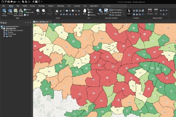
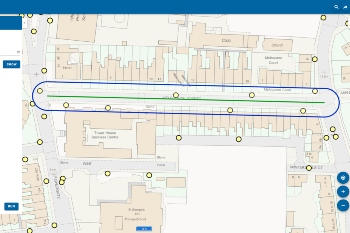
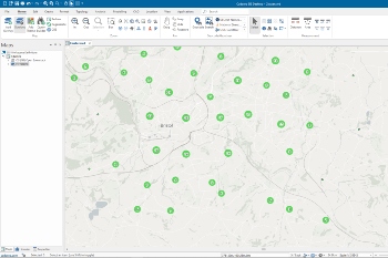 For analysis, a new cartogram function will be an effective alternative when presenting visualisations to stakeholders. Routing functionality, already a core strength of SIS, has been further extended to offer more routing options with the SIS routing engine, OSRM, and the multi-purpose routing engine, Valhalla. A new Route Matrix command allows users to carry out ‘many-to-many’ routing operations in a single, easily configurable step. The SIS route-finding engine now supports bi-directional route costs, for cases where, for example, the average speed in one direction on a road is faster than in the other direction. This can be used with OS MasterMap® Highways Network with speed data.
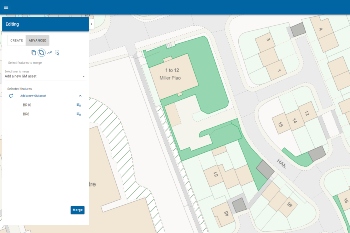
 New process operations have been added to SIS Desktop to speed up data capture and to aid data cleaning. Examples include automatically snapping field data capture to the underlying footprint on the OS MasterMap Topography Layer, and geocoding tools to convert postcodes or addresses in a Microsoft Excel spreadsheet to real-world locations using OS Data Hub APIs.
As a data entry time-saver, the table window has additional functionality such as improved search, copy and replace, and autocomplete. Microsoft Excel-type capabilities have been added so that users can now filter, more easily sort, and export to Adobe PDF. The table column Statistics command can now generate 3D pie and bar charts that can be exported as an image for embedding in reports and presentations.
SIS WebMap 9.1 is next-generation web mapping. With a modern redesign and an intuitive, browser-independent, mobile responsive interface, it offers a wider range of viewing, analysing, editing, and exporting options. Its Quick Search facility allows for fuzzy searches and enables access to web-based OS Data Hub APIs. It has a new Quick Access Drawer which allows users to see the available base mapping, to manage the transparency of the background, and to toggle business data layers on and off. Hovering or clicking on a feature drills down on the data and displays available attributes, even when multiple layers are selected.
 The introduction of ‘My Data’ to SIS WebMap adds significant new functionality, including creating themes and uploading and exporting data. ‘My Data’ offers a selection of options including Individual Values, Label, and Range themes. These can be particularly useful for highlighting important features on the map. ‘My Data’ now also supports uploading GeoJSON files to add business data to the map. ‘View list’ shows a tabular view of attribute data for a whole layer, or items on the screen. Entire spatial layers, or arbitrary collections of features, for example those in a particular area, can be exported as a GeoJSON file. The ‘Save features’ option enables user-defined themes or GeoJSON data to be saved between sessions, allowing anything created previously to be available to view and analyse in the future.
The ‘Query’ option has been extended, to provide additional search and buffer options. Query results create a new overlay in the map and also displays the results in a table window, allowing filters to be applied, and the results to be exported.
 Functionality for embedded maps has also been enhanced and now offers information pop-ups on cursor hover. As in the previous version, SIS WebMap 9.1 can be seamlessly integrated with business intelligence tools such as Microsoft Power BI.
Edit continues to bring editing capabilities to SIS WebMap, such as creating new data, editing existing data, and even deleting data. Users can now take advantage of single-click data capture, copying features between overlays, and merging or combining existing features.
SIS WebMap can be security-enabled to limit access to editing and to the available print templates. Maps can be printed up to A0 in size and published to PDF at any size.
 In addition, SIS WebMap 9.1 benefits from core SIS 9.1 enhancements such as cluster themes, and default Processes for snapping and single-click data capture.
The geospatial web services engine GeognoSIS is faster than ever with simplified and streamlined map and service management. Maps and their supporting files can now be synchronised between SIS Desktop and GeognoSIS, without requiring direct access to the server. This allows end-users to be more self-sufficient, and server security to be tightened. GeognoSIS Dashboard has been added for monitoring the performance and resources being used by GeognoSIS.
Cadcorp SIS is widely used around the world in both the public and private sector, notably in emergency services, government, land and property, environment, energy, infrastructure, and insurance. SIS 9.1 is a functionally rich GIS designed to meet the growing geospatial needs of these organisations and to support users ranging from experienced, highly skilled GIS professionals to members of the public. The software is available in the cloud, or as a download for a local installation.
Martin Daly, Technical Director at Cadcorp commented: “SIS 9.1 is a significant release, including a wide range of new functionality. We always strive to make the complex simple, and the simple fast, both by making all of our user interfaces more intuitive, and by improving performance. This release is no different. While there are many visible and functional changes, there have also been considerable, invisible, underlying technological changes that make the whole SIS 9.1 suite the most advanced version yet.”
For more information on Cadcorp SIS 9.1, visit https://cdcp.io/sis9-1.